


|
|
Kathimerini
Egnatia digs uncover the roman equivalent of interstate highway
By Costas Kantouris - The Associated Press
July 29th, 2005
Culture Ministry officials have unearthed extensive traces of the second-century-BC highway, which was built with safety features to protect even the clumsiest charioteer.
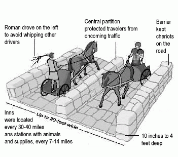
It was up to 30 feet wide (9 meters) in places and was dotted with safety features, inns and service stations.
«This was a busy road, and the Romans managed to make it completely functional,» archaeologist Polyxeni Tsatsopoulou told The Associated Press.
Built between 146 and 120 BC under the supervision of the top Roman official in Macedonia, proconsul Gaius Egnatius, the highway ran from the Adriatic coast in what is now Albania to modern Turkey, giving Rome quick access to the eastern provinces of its empire.
Ancient engineers did such a good job that the Via Egnatia remained in use for some 2,000 years, sticking to its original course even as its paving slabs were plundered for building material. But over the last century, what's visible of it has dwindled to less than 3 kilometers (2 miles) in total.
Now it is being reincarnated as the Egnatia Highway spanning northern Greece and set for completion in 2008.
This 680-kilometer (425-mile) highway costing 6.5 billion euros (US $7.9 billion) runs more or less parallel to the Roman road and crosses it several times.
An excavation near the town of Komotini, some 270 kilometers (168 miles) east of
Thessaloniki, revealed the Romans' sophisticated road-building techniques.
A central partition of large stones protected charioteers from oncoming vehicles, with similar barriers on the verges.
«This prevented chariots, wagons and carts from skidding off the road,» Tsatsopoulou said.
She said drivers held the reins with their right hand and wielded their whip with the left, so the Romans made drivers stay on the left to avoid the lash of oncoming riders and keep road-rage incidents to a minimum.
There were inns every 50 to 64 kilometers (30 to 40 miles), and post stations, the Roman equivalent of gas stations, every 11 to 23 kilometers (7 to 14 miles).
«These post stations had spare beasts, as well as... vets, grooms and shoesmiths,» Tsatsopoulou said.
|
1.jpg)
Via Aegnatia close to Philippi
Image courtesy of www.HolyLandPhotos.org
The ancient GuardRail
|
Archaeologists also discovered ruins of military outposts, checkpoints and camps, with guard posts built near narrow passes to curb highway robbery.
Culture Ministry officials hope to turn the surviving highway remains into an archaeological walk for tourists, Tsatsopoulou said.

|
|
|