


|
|
The roman bridge at Corbridge will be rescued
May 13th, 2004
The roman bridge in Corbridge will be rescued in a major archeological dig.
The excavation, to the west of the present village bridge towards Corstopitum roman site, will begin next summer, thanks to a 303,500 british pounds grant from a Lottery Fund.
It will bring visitors into the district and help raise the profile of Corbridge, Roman Corbridge, and Hadrian’s Wall in general, and will help benefit local businesses and tourism and support the local area.
The project will also run outreach programmes and organisers are keen to include schools, community groups and the general public to join in, help and become a part of history.
Margaret said: We want to have an outreach programme so that we can have activities, go into schools, do talks and make arrangement for groups to join us.
We are keen to make sure that there is plenty of access to information, and that we can have temporary exhibitions. We really want to get the community involved.
The bridge, believed to have once been an elaborate build complete with statues and monumental arches, was threatened with destruction by river erosion at Corbridge, which is in the Hadrian’s Wall World Heritage Zone.
As well as its functional use, the bridge was built to proclaim the power of the Roman Empire, particularly the Imperial House, and its importance was reflected in its scale and decoration.
Experts hope to find out what happened after the bridge collapsed. They believe the settlement, now known as Corbridge, moved down river to a place where it could be forded.
Volunteers and trainees will help with all aspects of the work, near the Corbridge Roman site Corstopitum, and will help reconstruct the bridge on the river bank.
There will also be a website with news of the latest discoveries at the site which is one mile west of the modern bridge at Corbridge.
The report from the English Heritage
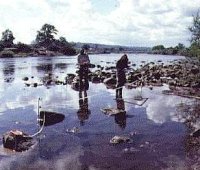
An evaluation was carried out on 2 structures beside the River Tyne under threat from erosion. These were the southern abutment of the Roman bridge and a structure on the northern side, which can now be identified as an Anglo-Saxon watermill. The work, which was jointly funded by EH and Northumberland County Council and undertaken by Tyne and Wear Museums, established these as monuments of national importance and assessed the extent of the threat from erosion. The study area lies at the bottom of the escarpment occupied by the Roman site of Corbridge. The present village of Corbridge is c 1km to the east, and was founded in the Anglo-Saxon period; it is assumed that the collapse of the Roman bridge caused the settlement shift to a location where the river could be forded.
The bridge carried Dere Street, which approached from the south-east. The line of the bridge is marked by the remains of 6 stone piers on the river bed, and the drought conditions of 1995 allowed a brief appraisal to be made of these. Although the position of the northern abutment is unknown, it is likely that the bridge crossed the original course of the river at right angles. Subsequent changes in course have been considerable and the remains of the abutment, occupying an area 11.2m by 6.4m and built of large dressed stone blocks, now lie in shallow water. In recent years masonry has also been exposed on the bank, as walkers have eroded the turf.
Downstream from the point where the line of the bridge meets the bank is a level shelf of boulders, cobbles, and gravel, covered by shallow water, extending out from the bank for a distance of 1220m before dropping steeply into the main channel. At the eastern end of the shelf, c 90m downstream, are the remains of the watermill. The edge of the shelf probably represents the waterline in Anglo-Saxon times, with the watermill standing on a low terrace, now flooded. The submerged remains occupy an area 18m by 7m and consist of a platform of large dressed blocks derived from the Roman bridge and large timbers for which radiocarbon dates in the 9th and 10th centuries have previously been obtained.
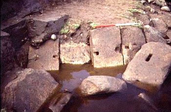
Survey and limited excavation of the bridge identified the masonry on land as a road ramp, in use with the abutment, although not bonded into it. The core of the ramp was mainly of rubble but included large worked blocks. A retaining wall at the south-east side was stepped up into the bank and ran roughly at right angles to the line of the bridge. Four courses survived, composed of worked blocks, the average size of which was 1m by 0.5m by 0.3m. The base of the revetting had been undermined by scouring, causing the masonry to slide forward; a line of blocks, originally joined by iron bar clamps (since robbed), lay tilted at an angle of 45 degrees. Masonry fallen beyond the edge of this revetment included 2 large moulded blocks with slots in their upper faces, probably to carry a balustrade, and an octagonal moulded plinth, 0.8m across, interpreted as the support for a statue base. These must represent the topmost courses of the ramp, the first to collapse when their metal clamps were robbed. Stone from the lower courses would have been removed by later stone-robbers. Planning of the abutment in the water revealed important structural details not recorded by previous survey in the 1960s, as well as indicating the results of continuing erosion.

|